

Volcanoes: When the Forces of Nature Become a Danger
Dr. Anselm Smolka
December 28, 2007
Dr. Anselm Smolka
Munich Re
Worldwide, around 550 volcanoes are classed as being active. Each year, between 50 and 65 of them erupt. The 1980 eruption of Mount St. Helens in the US state of Washington demonstrated the disaster potential of volcanoes. Since then, Munich Re has been considering the question how much risk volcanic eruptions involve.
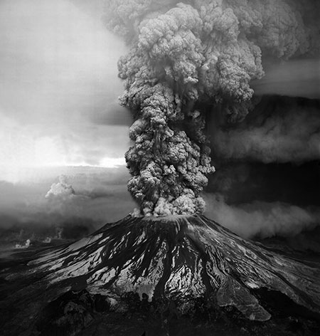
Photo: The eruption of Mt. St. Helens in 1980 was the worst volcanic disaster in U.S. history. At 8:32 a.m. on May 18, 1980, a 5.1 magnitude earthquake struck under Mt. St. Helens. Within ten seconds, the bulge and surrounding area fell away in a gigantic, rock avalanche. The avalanche created a gap in the mountain, allowing the release of pent-up pressure that erupted laterally in a huge blast of pumice and ash. The noise from the blast was heard as far away as Montana and California; however, those close to Mt. St. Helens reported hearing nothing.
The avalanche, huge to begin with, quickly grew in size as it crashed down the mountain, traveling around 70 to 150 miles per hour and destroying everything in its path. The blast of pumice and ash traveled northward at 300 miles per hour and was a raging hot 660° F (350° C). The blast killed everything in a 200-square mile area. Within ten minutes, the plume of ash had reached 10 miles high. The eruption lasted nine hours.
For the scientists and others who were caught in the area, there was no way to outrun either the avalanche or the blast. Fifty-seven people were killed. It is estimated that about 7,000 large animals such as deer, elk, and bears were killed and thousands, if not hundreds of thousands, of small animals died from the volcanic eruption.
Today, just as over 25 years ago, it is still true to say that - with the exception of extremely rare major meteorite impacts - there are no other natural events that can devastate such wide areas with comparable intensity and suddenness as volcanic eruptions. Their direct effects: lava, mud, and pyroclastic flows, glowing clouds, ash eruptions, and ash deposits. The indirect effects: climate change. The losses: besides the direct losses, disruption of air transport and shipping and crop failures.
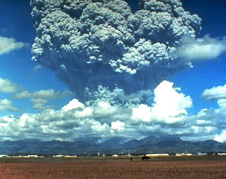
Photo: In June 1991, the second largest volcanic eruption of the twentieth century* took place on the island of Luzon in the Philippines, a mere 90 kilometers (55 miles) northwest of the capital city Manila. Up to 800 people were killed and 100,000 became homeless following the Mount Pinatubo eruption, which climaxed with nine hours of eruption on June 15, 1991.
In the recent past, eruptions of Pinatubo (Philippines, 1991), Tavurvur (Papua New Guinea, 1993), and La Soufrière (Montserrat, 1995-97) have caused considerable insured losses, amounting to several tens of millions of US dollars in each case. The biggest eruption was that of Pinatubo, the climatic effects of which were felt worldwide. Aerosol-forming sulphur dioxide molecules got into the upper atmosphere, causing the average global temperature to fall by half a degree.
CITIES AT RISK
Worldwide, around 500 million people live near volcanoes, the majority of them in cities. Auckland in New Zealand, for example, lies directly in a volcanic area. As a probabilistic exposure study shows, however, it is not the small volcanoes in the urban area that pose the main risk but the volcanoes situated some 200 km to the southeast and 260 km to the south of the city, some of them highly explosive - such as Mount Egmont (or Mount Taranaki in Maori). The main danger would come from ash deposits following an eruption.
Urban areas are also at high risk in Japan. Besides Tokyo, there are a number of cities with more than a million inhabitants like Nagoya, Kyoto, and Yokohama that are threatened. The area in the vicinity of Fujiyama, where 20 million people spend their holidays each year, would be particularly affected.
The area around Naples in Italy is also at risk. In past centuries, Vesuvius has erupted roughly every 30 years. If there were to be another eruption on the scale of the one that occurred in 79 BC, it is estimated that the property damage would run to around US$ 40bn, only a tiny proportion of which would be insured as things currently stand. Whether there is currently any risk though is disputed.
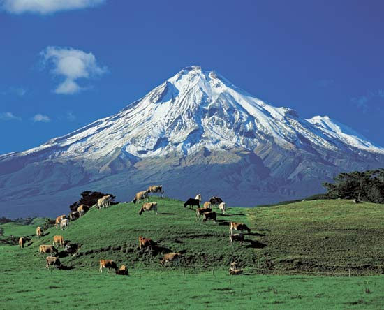
Photo: Cows graze on green pastures against the backdrop of Mount Taranaki (or Mount Egmont), a snowcapped volcano. The Taranaki region is one of New Zealand's most important areas for dairy farming. In all, the country is home to about 2.5 times as many cattle as people.
However, researchers have been getting more worried since 2001 when they discovered a 400-km2 magma lake under Vesuvius which extends below the ground to beneath the hills of the Phlegraean Fields in northwest Naples. More than three million people live in this region, which means that the Phlegraean Fields probably pose a greater threat than Vesuvius itself. They are an example of a supervolcano, a popular-science term for volcanoes that have caused eruptions with a volume of 300 km3 or more.
SUPERVOLCANOES - THE BIG DANGER?
They have no cone, are to be found under all continents, probably under the sea, too, and erupt very rarely. They are nevertheless one of the greatest natural hazards. Following an eruption, the roof of the magma chamber caves in, leaving a large basin known as the caldera. Supervolcanoes have very long periods of dormancy - tens to hundreds of thousands of years. The Geological Society of London produced a report on them for the British government which revealed that, besides the Phlegraean Fields near Naples, there is a second supervolcano in Europe, namely in the Eastern Mediterranean near the island of Kos. The last eruption of the Phlegraean Fields happened 35,000 years ago and was gigantic, with around 50 to 100 times the amount of material being ejected as in the 1991 eruption of Pinatubo. Supervolcanoes are also believed to lie beneath New Zealand, Kamchatka, the Philippines, the Andes, in Middle America, the United States, Indonesia, and Japan. The vast magma chambers lie at depths of 5-20 km. One such chamber beneath Yellowstone Park, for example, is twice the size of Luxembourg. Current satellite remote sensing observations show that parts of the caldera rise by several millimetres each year. An eruption would have unimaginable local and global consequences. However, the risk is not considered to be acute.
Examples of Major Cities Situated Near Active Volcanoes
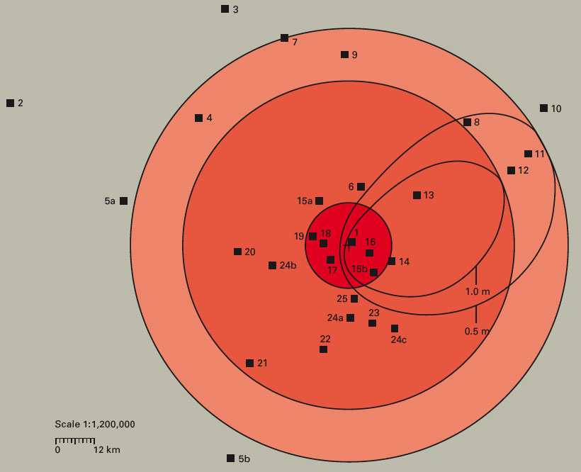
1 Auckland (Auckland volcanic field)
2 Vancouver (Mt. Baker)
3 Seattle (Mt. Rainier)
4 Tacoma (Mt. Rainier)
5 a, b Portland (Mt. Hood, Mt. St. Helens)
6 Mexico City (Xitli)
7 Surabaya (Ardjuno-Welirang)
8 Semarang (Sundoro-Sumbing)
9 Manila (Taal) 10 Tokyo (Fujiyama)
11 Kawasaki (Fujiyama)
12 Yokohama (Fujiyama)
13 Guatemala City (Agua Volcano)
14 San Salvador (San Salvador Volcano)
15 a, b Managua (Masaya-Nindiri, Apoyeque)
16 Quito (Pichincha)
17 Arequipa (El Misti) 18 Kagoshima (Sakurajima)
19 Naples (Vesuvius)
20 Nagasaki (Unzendake)
21 Shizuoka (Fujiyama)
22 Yogyakarta (Merapi)
23 Catania (Etna)
24 a, b, c San José (Barba, Irazú, Poás)
25 Bandung (Tangkuban Prahu)
The cities are shown in terms of their distance from and direction to the respective volcano located at the centre of the diagram. Some cities are exposed to roughly the same threat from several volcanoes and are shown more than once.
The two outer zones mark the extent of a 0.5 or 1 metre covering of ash in the event of an eruption of the order of magnitude of the Krakatau eruption of 1883. The two isolines (on the right) represent the area actually affected, taking as an example the eruption of the Taupo volcano in New Zealand, which happened in around 130 AD. The prevailing winds mean that the ash does not spread symmetrically in a circle. The inner zone indicates the approximate extent of the area that, depending on a volcano’s activity, can be affected by phenomena like lava flows, mudflows, and glowing clouds.
EFFECTS OF MAJOR VOLCANIC ERUPTIONS ON THE GLOBAL CLIMATE
A major volcanic eruption not only has an impact regionally; it also affects the global climate. The triggers of such changes are layers of aerosols that form following an eruption. These spread around the earth and reflect part of the solar radiation back into space, causing a fall in the earth's temperature.
Hitherto, effects on the global climate have not been the focal point of quantitative risk considerations. In 1992 - the year following the eruption of Pinatubo in the Philippines - the temperature worldwide fell by an average of half a degree Celsius. Damaging effects on the global climate have been documented before, however, particularly following the eruption of the Laki Rift in Iceland in 1783 and the eruption of Tambora on the island of Sumbawa (Indonesia) in 1815 - the biggest historical eruption, with around 10 times the volume of ejecta as from Pinatubo.
However, it is not always possible to provide unequivocal proof of a direct connection between individual observations. When the events are considered in their entirety, however, a coherent picture definitely emerges.
ECONOMIC EFFECTS OF VOLCANIC ERUPTIONS
For a city like Tokyo, for example, with its 20 million inhabitants, a volcanic eruption would be catastrophic. When Fujiyama last erupted just under 300 years ago - in December 1707 - ash rained down on the city for two weeks, even though it lies 100 km away. If it were to erupt again, public life would grind to a halt.
Etna, the biggest volcano in Europe, likewise caused enormous damage when it erupted in 2001 and again in 2002/03. In 2002, the ash rain alone caused economic losses of around €800m.
Eruptions like Laki and Tambora not only produce direct material losses; they are also likely to have a disruptive effect on air traffic and shipping and lead to immense crop failures. According to forecasts by scientists at the Geological Society of London, agriculture would be impossible in many places. Crops will even be destroyed by a layer of ash just 1 cm deep.
Another scenario has also attracted considerable attention in recent years: if the west flank of Cumbre Vieja on La Palma were to break off as a result of the volcano erupting, this would cause a tsunami. The tidal wave would have a massive impact on the Canary Islands and, to a lesser extent, on the southwest coast of the Iberian peninsula and the northwest coast of Africa. However, more recent findings have toned down the initial forecasts on the propagation of the wave. Research has revealed that the height of the wave on the other side of the Atlantic would reach significant levels only in the northeast of South America.
SIMULATION MODELS
An international team of volcanologists and meteorologists under the direction of the Max Planck Institute for Meteorology in Hamburg and GEOMAR (Research Centre for Marine Geosciences) in Kiel studied how volcanic activity affects the climate. The aim was to produce a computer simulation of just what gets into the upper atmosphere. They succeeded in designing a numerical model that simulates the development of the eruption cloud and its interaction with the environment. ATHAM (Active Tracer High Resolution Atmospheric Model) is recognised in specialist circles, and many volcanologists worldwide have adopted it, one reason probably being that, with previous models, each type of particle had to be calculated separately - which was time-consuming and mostly ineffective.
ATHAM, on the other hand, analyses the particle ensemble as a whole and also takes account of external factors such as ambient temperature. The application has a relatively simple structure, consisting of a stable core calculation that can be supplemented as required with single, individually adjustable modules. Up to now, for example, calculations have been based on a simple cloud model, whereas ATHAM makes it possible to incorporate a more sophisticated cloud model.
FREQUENCY OF VOLCANIC ERUPTIONS
The effects of large volcanic eruptions require the occurrence probability to be looked at not only on a local basis but also globally. Unfortunately, major eruptions have not been fully documented - either in historical or in geological terms. Using statistical methods and based on data available so far, experts have calculated a worldwide occurrence probability of once in 500-1,000 years. It applies with respect to the magnitude of the Tambora eruption of 1815. In order to be able to arrive at more precise values of the occurrence probability in future, Munich Re is currently supporting a research project under the overall control of the Department of Earth Sciences at the University of Bristol (UK). The aim is to extend the database for major eruptions from the current 2,000 years to 10,000 years.
As part of these statistical frequency estimates, a new scale for the strength of volcanic eruptions was also developed: volcanic magnitude, which is based on the mass of the volcanic products ejected in an eruption. The volcanic explosivity index (VEI) used hitherto is based on volume. The problem is that the density of volcanic rock can differ, which means that the volume bears no unequivocal relationship to the mass. Consequently, the VEI does not give adequate consideration to the different types of eruption. The definition of mass is always the same, however. Volcanic magnitude therefore creates a uniform data basis for further research. For each full step on the volcanic magnitude scale, the mass increases by a factor of ten. The Tambora eruption of 1815 has a magnitude of 7- on this scale. The biggest eruption in the last 100,000 years - that of Toba in Indonesia - reaches a magnitude of 8+. The event in the Phlegraean Fields 35,000 years ago would have had a magnitude of 7+.
VOLCANIC ERUPTION - AN INSURABLE RISK?
In principle, volcanic eruption is an insurable risk. Apart from a few exceptions, however, the rarity of loss occurrences means that the technically necessary rate is marginal. Volcanoes like Vesuvius are intensively monitored by measuring instruments - an eruption would therefore hardly come as a surprise. However, it would not be possible to estimate the strength of an imminent eruption. Any action taken in response to an advance warning - in other words, an evacuation - would constitute a huge logistical challenge, as more than a million people live within 10 km of the crater. A string of craters extends along the Laki Rift in Iceland. The probability of an eruption like the one in 1783 is put at once in around 1,000 years.
www.standeyo.com/NEWS/07_Earth_Changes/071228.volcano.dangers.html