
Undersea Volcano Caught on Camera
Putting together more than 50,000 sea floor images, along with 10 exploratory dives with the Alvin submarine, an unprecedented map has been pieced together showing 22 million cubic meters (13,670 cubic miles) of new lava coming out of the East Pacific Rise -- a seafloor spreading center off the Pacific coast of Mexico.
The area covered by the recent eruption is equivalent to metropolitan Oklahoma City, or nearly half of Manhattan. The discovery that an eruption was underway, however, was sort of an accident.
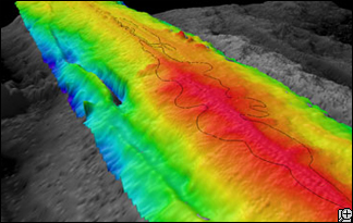
Researchers used multibeam sonar to compile this topographic map of a portion of the East Pacific Rise where undersea volcanic eruptions were caught on camera. The black line shows the extent of the eruption. The new lava flow stretched more than 11 miles long and up to 2 miles wide. At the northern end of the eruption, lava poured from a fissure 2,000 feet away from the ridge crest, a process that has been thought to occur, but never, but never observed.
Researchers used multibeam sonar to compile this topographic map of a portion of the East Pacific Rise where undersea volcanic eruptions were caught on camera. The black line shows the extent of the eruption. The new lava flow stretched more than 11 miles long and up to 2 miles wide. At the northern end of the eruption, lava poured from a fissure 2,000 feet away from the ridge crest, a process that has been thought to occur, but never observed.
"We had an array of seismometers down there that weren't coming back," said marine geophysicist Maya Tolstoy of Columbia University's Lamont-Doherty Earth Observatory. They were, in other words, buried by lava, she explained.
"We had seen increasing seismicity, and we suspected an eruption," she told Discovery News. So when eight of 12 ocean-bottom seismometers went missing in 2006, she instructed her assistants to look for telltale volcanic eruption chemicals in the water. They found them.
That discovery led another team of researchers, led by Adam Soule of Woods Hole Oceanographic Institution, to undertake the dives and take the images to chart the extent of the eruption. Their results are reported in the December issue of the Geological Society of America's journal Geology.
"We knew something weird was going on," said Woods Hole's Dan Fornari, a coauthor of the Geology report. "What we needed to do was go there and map the heck out of it."
The results are some rare images of brand-new lava meeting older lava and detailed maps showing how the new lava followed channels in older lava beds. More significantly, the eruption is a real-time example of how the Earth makes new crust -- which is what happens at ocean spreading centers like the East Pacific Rise.
"This is basically where oceanic crust is forming," said Donna Blackman, chair of the Ridge 2000 Program, which focuses research on ocean spreading centers. "This is the process that forms most of the skin of the Earth."
The East Pacific Rise is a central part of such research, Blackman said, because unlike other active spreading centers, it is in waters that are relatively easy to reach year-round, and there's a lot of earlier data there with which to compare.
dsc.discovery.com/news/2007/12/04/undersea-volcano.html